gunung ledang hiker's trail (from Gate B)

Share your trip photos, tracklogs, experience & tips. Ask the locals info about your planned destination.

Moderators: Moderators, Regional Mappers

Forum rules
1. Be nice to each other and respect the moderators. Post in normal font size, color and weight. Follow Nettiquette
2. NO out of topic. Discuss matters pertaining MFM community and forum only.
3. NO abuse, profanity and insults
4. NO spamming, cross posting and opening of duplicate topics
5. NO advertisement post or link
6. NO post/link to warez, cracks, serials or illegally obtained copyrighted content
7. Each message posted is owned by and is the opinion of the original poster. Neither mfm nor its owner or moderators are legally responsible for anything posted on the forum
User avatar
snail-works
Valued Contributor
Posts: 204
Joined: Mon Sep 22, 2008 9:53 am
Location: from kuala kangsar, now active in JB and Singapore
Contact:

gunung ledang hiker's trail (from Gate B)

Postby snail-works » Tue Mar 17, 2009 3:13 pm

Hikers had rated Gunung Ledang (Mount. Ophir) as the 6th difficult summit trails among Malaysia mountains. There's 4 trails can go up to the summit. Here's the hiker's trail from Gate B, Pusat Operasi Taman Negara Gunung Ledang. Total 8 checkpoints (CP) along the trail. The terrain before CP5 is quite gentle uphill. The KFC session is after CP6 up to CP 8 (summit) :mrgreen: ... Along the way there's ropes and ladders to assist. This is not a leisure jungle walk.

We have not much time to enjoy the scenery due to we were late to the trailhead. There's rule that if anybody cannot reach summit before 3.00pm, he/she must turn back from the point where he/she is. Hikers are not allowed to camp overnight in the park.

I hope next time i can have more time to explore the waterfalls and flora here.

(note : KFC = Killing Fitness Centre :mrgreen: )

gunung ledang - from far view
Image

pusat operasi taman negara gunung ledang
Image

welcome board
Image

clear signboard along the way that show where you are now
Image

a small cascade near CP5 sg. tiga segi
Image

part of KFC
Image

CP6 gua kambing
Image

guide is guiding us how to cross the big boulder
Image

continue fo rock ascent
Image

view from the summit
Image

the cloud was so near to us
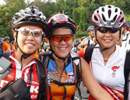
Image

'i luv summit'
Image
You do not have the required permissions to view the files attached to this post.
Lost in contour lines, my waterfalls diary ~ www.waterfallquest.jimdo.com ~

User avatar
robo
Senior Mapper
Posts: 1321
Joined: Fri Sep 19, 2008 12:34 pm
Location: Johor Bahru
Contact:

Re: gunung ledang hiker's trail (from Gate B)

Postby robo » Tue Mar 17, 2009 6:29 pm

Hi Snail-works,
Thanks for sharing. Beautiful pictures!
Tracks will be update.
Please submit your Tracklogs & POI here : http://malfreemaps.com/viewtopic.php?f=16&t=11636

User avatar
tlchuan
Polygon Mapper
Posts: 2010
Joined: Wed Sep 17, 2008 8:15 am
Location: Subang Jaya (x10 & Oregon 300)Garmin 255w sgmy, 2575RLM, Wayway 5035
Contact:

Re: gunung ledang hiker's trail (from Gate B)

Postby tlchuan » Tue Mar 17, 2009 6:58 pm

:cry: :cry: unfortunate can't join the GG must blame my friend for it, ask him to bring me there on honey moon :evil:
Image

exz8
Polygon Mapper
Posts: 753
Joined: Fri Sep 19, 2008 1:37 pm
Location: Papago R5800

Re: gunung ledang hiker's trail (from Gate B)

Postby exz8 » Sat Jul 11, 2009 12:11 pm

i notice there is a road if want to reach the summit by car. near telekom...
entering about 10 minutes with unpaved, then until summit, all are paved.
you know that?

User avatar
keong8260
Regional Mapper
Posts: 1828
Joined: Fri Sep 19, 2008 4:29 pm
Location: Alor Setar (60CSx, Nuvi, Papago, Polnav, Galactio, Compass, Parang, Gun)
Contact:

Re: gunung ledang hiker's trail (from Gate B)

Postby keong8260 » Mon Jul 20, 2009 11:34 pm

tlchuan wrote::cry: :cry: unfortunate can't join the GG must blame my friend for it, ask him to bring me there on honey moon :evil:


Ya lah... because your friend don't know how to wear helmet... :lol:

User avatar
fauzee
Polygon Mapper
Posts: 1243
Joined: Fri Feb 06, 2009 9:19 pm
Location: JB and Muar -200W & 60Csx

Re: gunung ledang hiker's trail (from Gate B)

Postby fauzee » Tue Jul 21, 2009 10:46 am

:good: :tq: really nice Shots.. :prayer:
~Lost Is Nothing~
...PLEASE INSTALL THE LATEST MAPS BEFORE DOIN' SOMETHIN'...

User avatar
tuah
Champion Tracker
Champion Tracker
Posts: 5441
Joined: Wed Sep 17, 2008 8:02 pm

Re: gunung ledang hiker's trail (from Gate B)

Postby tuah » Tue Jul 21, 2009 11:01 am

Congratulations! You have reached the summit. =D> =D> =D>

User avatar
shump
Posts: 82
Joined: Tue Nov 04, 2008 11:48 am
Location: Sungai Petani,Kedah
Contact:

Re: gunung ledang hiker's trail (from Gate B)

Postby shump » Tue Jul 21, 2009 1:10 pm

wahh..nice pic arr. Hope to go there one day.. :peace:
Garmin Nuvi 255w(US) - Back On Track Again

singfire
Posts: 2
Joined: Fri Oct 03, 2008 3:48 pm

Re: gunung ledang hiker's trail (from Gate B)

Postby singfire » Tue Aug 18, 2009 5:22 pm

Nice photos you captured there. The last time I climbed was like more than 20 years ago. Seems there is a operation point now which is a good thing, I think due to some lost trekkers. So is getting a guide a must now?


Return to “Holiday & Travel”

Who is online

Users browsing this forum: No registered users and 26 guests