i-Blue 747 GPS Data Logger - A short Review

Share general news, ideas and discussions about GPS and GPS navigation

Moderators: Moderators, Regional Mappers

Forum rules
1. Be nice to each other and respect the moderators. Post in normal font size, color and weight. Follow Nettiquette
2. Remain on topic. Discuss general GPS and GPS navigation topics only
3. NO abuse, profanity and insults
4. NO spamming, cross posting and opening of duplicate topics
5. NO advertisement post or link
6. NO post/link to warez, cracks, serials or illegally obtained copyrighted content
7. Each message posted is owned by and is the opinion of the original poster. Neither mfm nor its owner or moderators are legally responsible for anything posted on the forum
User avatar
spclocktower
Valued Contributor
Posts: 108
Joined: Fri Nov 14, 2008 3:26 pm
Location: 08000 Sungai Petani, Kedah
Contact:

Re: i-Blue 747 GPS Data Logger - A short Review

Postby spclocktower » Fri Dec 05, 2008 4:29 pm

norwadi wrote:
wiraone wrote:Waa.. more and more buying this iBlue thingy.. but hmm.. RM274.08 is a bit high from ebay. Did you bought from Uranium's UK listing? Mine is a bit low (as shown in my credit card transaction):

04-Nov-2008 01-Nov-2008 PAYPAL *URANIUM99 4029357733 HK 000233.90 RM236.23

Would you mind tell me the links where you bought it? I'm thinking of getting one. 8-)
:tq:


Mine is RM222.09 (using HSBC CC)

02 Dec 2008 04 Dec 2008 PAYPAL *BSINTERNATI HK RM222.09
Nuvi 205 + i-Blue 747 GPS logger + (N)bokia 5800 with Garmin XT

amry
Posts: 43
Joined: Tue Nov 04, 2008 11:34 am
Location: Setapak / Cyberjaya

Re: i-Blue 747 GPS Data Logger - A short Review

Postby amry » Sat Dec 06, 2008 1:02 pm

amry wrote:Currently, I can import tracks from the 747 using the GPS Photo Tagger software. Using the "Export Tracks" function to export it to GPX format, it will simply export tracks only. How do I go about to have it export the waypoints I marked using the 747 along with the tracks to a MapSource-compatible format?

A working solution I found thru trial and error, to share with all:
1. In GPS Photo Tagger application, export the tracks you want as KMZ (menu File -> Export as KMZ...)
2. Rename the generated .KMZ file to .ZIP
3. Extract a file named "track.kml" from inside the .ZIP file
4. Use GPSBabel to convert that track.kml to another MapSource-compatible format i.e GDB

The generated GDB file should have the tracks and waypoints appearing exactly as the originally recorded ones.
Garmin Nuvi 205 :: i-Blue 747 GPS Data Logger

User avatar
NoX
Posts: 167
Joined: Wed Sep 24, 2008 10:08 pm

Re: i-Blue 747 GPS Data Logger - A short Review

Postby NoX » Tue Dec 23, 2008 12:35 am

amry wrote:A working solution I found thru trial and error, to share with all:
1. In GPS Photo Tagger application, export the tracks you want as KMZ (menu File -> Export as KMZ...)
2. Rename the generated .KMZ file to .ZIP
3. Extract a file named "track.kml" from inside the .ZIP file
4. Use GPSBabel to convert that track.kml to another MapSource-compatible format i.e GDB

The generated GDB file should have the tracks and waypoints appearing exactly as the originally recorded ones.


.KMZ is a compressed version of .KML for Google Earth. GPS Photo Tagger can export the track to GPX, NMEA0183, KML and EXCEL also KMZ as you mentioned.

I normally export it out to GPX and convert to Mapsource without problem.

BTW : you can use Symbian S60 phones with GPS Track to do tracking with i-blue or other GPS receiver with BT also you vcan use the MTK Java program to control the i blue via your hand phone that inclusive of downloading its track log.

I'm using the cheapest one Nokia 6120 Classic, no problem,

Try download the symbian program here : http://www.getjar.com/products/17413/BT ... idletSuite

NoX

quantum
Polygon Mapper
Posts: 39
Joined: Fri Sep 19, 2008 10:45 am

Re: i-Blue 747 GPS Data Logger - A short Review

Postby quantum » Wed Dec 24, 2008 5:33 pm

anyone get i-blue 747 A+

66ch

or any 5hz track log ?

User avatar
ahbahari
Valued Contributor
Posts: 154
Joined: Sat Sep 20, 2008 7:04 am
Location: Johor - Nuvi255w; eTrex Vista HCx + Re radiating antenna
Contact:

Re: i-Blue 747 GPS Data Logger - A short Review

Postby ahbahari » Sat Jan 03, 2009 11:23 am

quantum wrote:anyone get i-blue 747 A+

66ch

or any 5hz track log ?


Looks better spec than i blue 747..
Come on Gunners..

User avatar
Buzz
Posts: 11
Joined: Sun Feb 15, 2009 12:08 pm
Location: Tiny Red Dot

Re: i-Blue 747 GPS Data Logger - A short Review

Postby Buzz » Sun Feb 15, 2009 12:19 pm

Firstly Hi to all in this forum, have been reading for a while and found this forum much more friendlier than MSM, you guys rocks :peace:

After reading this thread i took the plunge and ordered the 747+ last night. I have a trip to Kenyir next month hope i will be able to contribute some tracks :thumbsup:

User avatar
norwadi
Posts: 192
Joined: Sat Nov 22, 2008 9:17 pm
Location: Kuala Lumpur (Garmin nüvi 760)

Re: i-Blue 747 GPS Data Logger - A short Review

Postby norwadi » Sun Feb 15, 2009 11:19 pm

Buzz wrote:Firstly Hi to all in this forum, have been reading for a while and found this forum much more friendlier than MSM, you guys rocks :peace:

After reading this thread i took the plunge and ordered the 747+ last night. I have a trip to Kenyir next month hope i will be able to contribute some tracks :thumbsup:

Welcome to MFM.
Don't forget to feedback here when you get your i-blue. :thumbsup:
:welcome:

User avatar
uncle wong
Regional Mapper
Posts: 888
Joined: Wed Jan 21, 2009 12:57 am
Location: Kuala Lumpur - Selangor - Johor I did not have a GPS device
Contact:

Re: i-Blue 747 GPS Data Logger - A short Review

Postby uncle wong » Sun Mar 15, 2009 7:03 pm

Looking for Holux M-241 , ANY IDEA WHERE TO BUY ??
Enjoy the GPS’s life!

User avatar
Buzz
Posts: 11
Joined: Sun Feb 15, 2009 12:08 pm
Location: Tiny Red Dot

Re: i-Blue 747 GPS Data Logger - A short Review

Postby Buzz » Thu Mar 19, 2009 2:21 pm

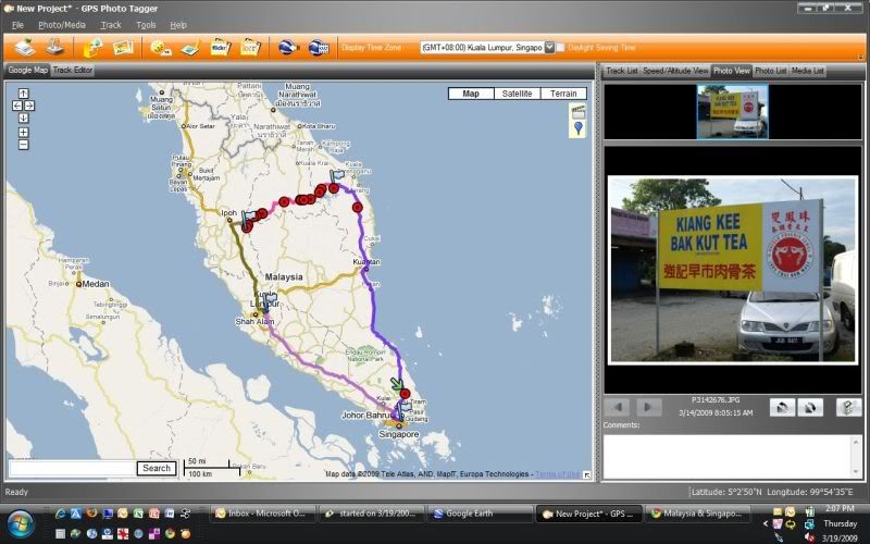
Just used my 747+ on my 5 days road trip to Road Kenyir, Cameron, and KL. Excellent! This is a screen shot showing the tracks as well as a picture i took of the Kota Tinggi Bak Kut Teh on my way up.
Image

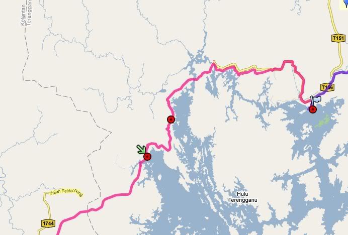
The roads were all fine except a short stretch from Kenyir to Gua Musang. Starting from Lat:5.123560, Lon:102.616255 to Lat:5.073388, Lon:102.584349. Very bumpy and full of pot holes but ordinary cars will not have any problems navigating this stretch, just need to go slow.
Image

Route 185 from Gua Musang to Cameron have numerous land slides but all the roads are still passable. Road repairs were underway.

User avatar
Buzz
Posts: 11
Joined: Sun Feb 15, 2009 12:08 pm
Location: Tiny Red Dot

Re: i-Blue 747 GPS Data Logger - A short Review

Postby Buzz » Thu Mar 19, 2009 2:37 pm

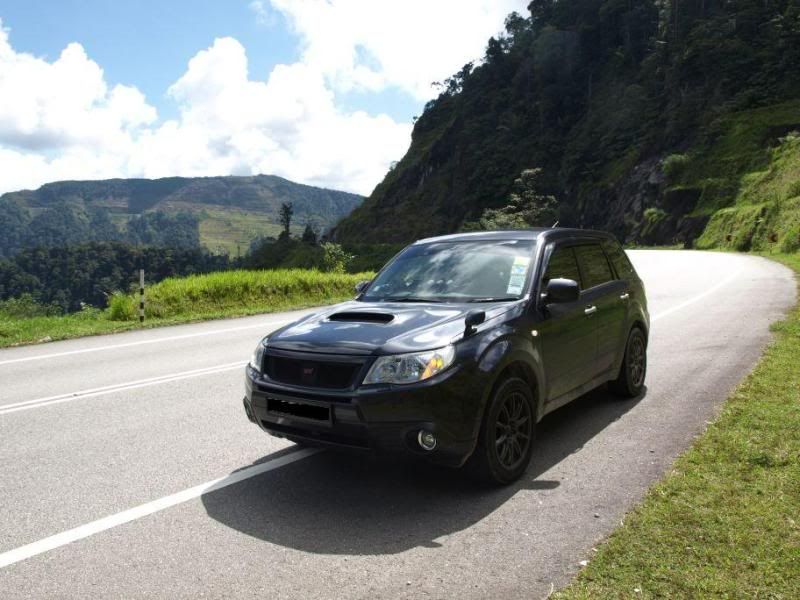
My photography skills is not up to par, so unable to capture the magnificent scenery. This is a shot of my car on the way down from Cameron on the way to Simpang Pulai.
Image

Malaysian you guys have it good :thumbsup:


Return to “General GPS Forum”

Who is online

Users browsing this forum: No registered users and 20 guests