mfm 110328
This is a one way alley which vehicles can only enter from Kitchener Road, and exit at Jln Besar.
Due to the proximity of tall buildings they block the signals thus the alley was not well tracked. However I have overlaid it with a hand drawn track.
Done! 224 - OngCC
Tracklogs for Singapore (2011)
Moderators: Chuah, Moderators, Regional Mappers
Forum rules
1. Be nice to each other and respect the moderators. Post in normal font size, color and weight. Follow Nettiquette
2. NO out of topic. This forum is strictly for feedback to our maps
3. NO posting of data copied from other source especially malsingmaps
4. NO abuse, profanity and insults
5. NO spamming, cross posting and opening of duplicate topics
6. NO post/link to warez, cracks, serials or illegally obtained copyrighted content
7. Each message posted is owned by and is the opinion of the original poster. Neither mfm nor its owner or moderators are legally responsible for anything posted on the forum
Re: Tracklogs for Singapore (2011)
You do not have the required permissions to view the files attached to this post.
Contribute exclusively to MFM. MSM don't get it !
Re: Tracklogs for Singapore (2011)
Update of Marina south pier not complete.
You do not have the required permissions to view the files attached to this post.
http://www.muarchunghwaosa.org/00-CHJB/jb2010cav.htm
Nuvi205 Nuvi57LM
GPSmap 60CSx
Nuvi1460
Nuvi205 Nuvi57LM
GPSmap 60CSx
Nuvi1460
Re: Tracklogs for Singapore (2011)
mfm v110411
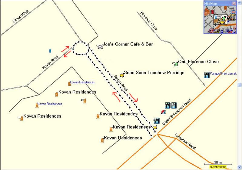
Changes in traffic direction for Simon Road and part of Kovan road.
Simon road is now a 2-way traffic. The road should look something like this

Changes in traffic direction for Simon Road and part of Kovan road.
Simon road is now a 2-way traffic. The road should look something like this

You do not have the required permissions to view the files attached to this post.
Contribute exclusively to MFM. MSM don't get it !
Re: Tracklogs for Singapore (2011)
V.110411,
Cp Jellicoe Road.
Thanks.
Done! 226 - OngCC
Cp Jellicoe Road.
Thanks.
Done! 226 - OngCC
You do not have the required permissions to view the files attached to this post.
Re: Tracklogs for Singapore (2011)
Ghim Moh Link,
No rstriction on directions at traffice light junction to and fro Commonwealth Avenue West and Dover Avenue. Road ends at HDB construction site at this moment.
Done! 228 - OngCC
No rstriction on directions at traffice light junction to and fro Commonwealth Avenue West and Dover Avenue. Road ends at HDB construction site at this moment.
Done! 228 - OngCC
You do not have the required permissions to view the files attached to this post.
Re: Tracklogs for Singapore (2011)
Tracklogs of some PCNs
Note that the Serangoon PCN has 2 Br. One Br goes towards Punggol Park whilst the other goes to Punggol Promenade
Note that the Serangoon PCN has 2 Br. One Br goes towards Punggol Park whilst the other goes to Punggol Promenade
You do not have the required permissions to view the files attached to this post.
Re: Tracklogs for Singapore (2011)
110523,
Sixth Avenue and Namly Crescent update. Pls refer .jpg and .gdb files.
Done! 232 - OngCC
Sixth Avenue and Namly Crescent update. Pls refer .jpg and .gdb files.
Done! 232 - OngCC
You do not have the required permissions to view the files attached to this post.
Re: Tracklogs for Singapore (2011)
Jurong East Update,
Summit Lane is renamed as Jurong Gateway Road, now it has traffic light juction on Boon Lay Way with official U Turn back to J. Gateway Road toward MRT station.
Gateway Link is with traffic light juction on Jurong Town Hall Road and another traffic light junction on Jurong Gateway Road.
Former loop of drop off/ pick up point near to Popular Book Shop is no more.
New pick up / drop off point (maroon colour) for buses is road side of newly opened Venture Avenue marked on .jpg file.
New pick up/ drop off point (red colour) for taxis and cars is marked on .jpg file.
Another official U turn from J. Gateway Road to J Gateway Road toward IMM is near former drop off point.
Refr. gdb and .jpg files.
Done! 233 - OngCC
You do not have the required permissions to view the files attached to this post.
Re: Tracklogs for Singapore (2011)
mfm 110620
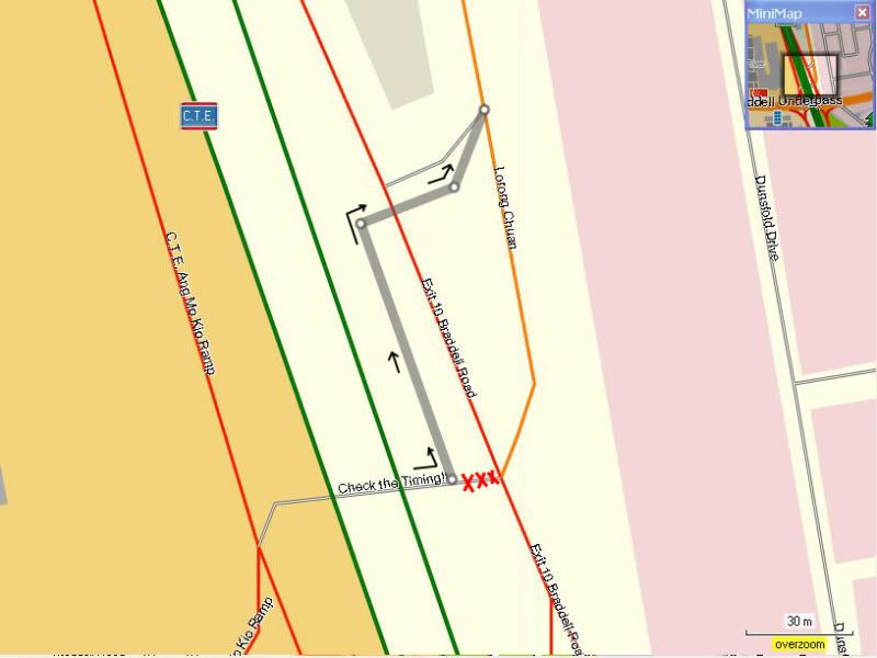
Re-alignment of link from Braddel Road to Lor Chuan

Done! 235 - OngCC
Re-alignment of link from Braddel Road to Lor Chuan

Done! 235 - OngCC
You do not have the required permissions to view the files attached to this post.
Contribute exclusively to MFM. MSM don't get it !
Re: Tracklogs for Singapore (2011)
Track for blk 441 - 452 Yishun.
The road connects Yishun Ave 11 and Yishun Ring Rd.
Unfortunately, my Garmin track is not very accurate, so I didn't submit the blk no.
They are all completed blks.
Done! 243 - OngCC
The road connects Yishun Ave 11 and Yishun Ring Rd.
Unfortunately, my Garmin track is not very accurate, so I didn't submit the blk no.
They are all completed blks.
Done! 243 - OngCC
You do not have the required permissions to view the files attached to this post.
Return to “Singapore Map Feedback”
Who is online
Users browsing this forum: No registered users and 39 guests
