
One-way access road to a housing estate, bypassing a major traffic light intersection. If you look at the latest satellite image in Google Maps of this area, you can clearly see how this road relates to the adjoining roads.
tympg 20160414 ramp to residential.7z
Thanks.
Penang Island Tracks Pt 4
Moderators: tympg, keong8260, Moderators, Regional Mappers
Forum rules
1. Be nice to each other and respect the moderators. Post in normal font size, color and weight. Follow Nettiquette
2. NO out of topic. This forum is strictly for feedback to our maps
3. NO posting of data copied from other source especially malsingmaps
4. NO abuse, profanity and insults
5. NO spamming, cross posting and opening of duplicate topics
6. NO post/link to warez, cracks, serials or illegally obtained copyrighted content
7. Each message posted is owned by and is the opinion of the original poster. Neither mfm nor its owner or moderators are legally responsible for anything posted on the forum
Re: Penang Island Tracks Pt 4
Garmin nüvi 2575R; Garmin eTrex Vista HCx; Android 5.0.1 Phone
Re: Penang Island Tracks Pt 4
Some newly completed apartment projects and their surrounding added/upgraded/removed roads. Note all the apartments here have plural words in their names.
tympg 20160414 new residential.7z
Thanks.
tympg 20160414 new residential.7z
Thanks.
Garmin nüvi 2575R; Garmin eTrex Vista HCx; Android 5.0.1 Phone
 Bro!
Bro!Re: Penang Island Tracks Pt 4
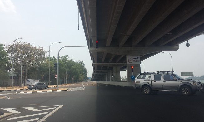
Bayan Lepas Expressway (Elevated)
The elevated expressway to facilitate access to the Penang 2nd bridge has been completed and is open to traffic. The mainstream media calls this elevated road Bayan Lepas Expressway (BLE) so we'll go with that. (The road below at ground level is still Tun Dr Lim Chong Eu Expressway.)
Other than the two ends, there are no exit/entry ramps on this elevated road. If you start from one end of this expressway, you will finish at the other end 3.3km later, no choice.
tympg 20160419 BLE.7z

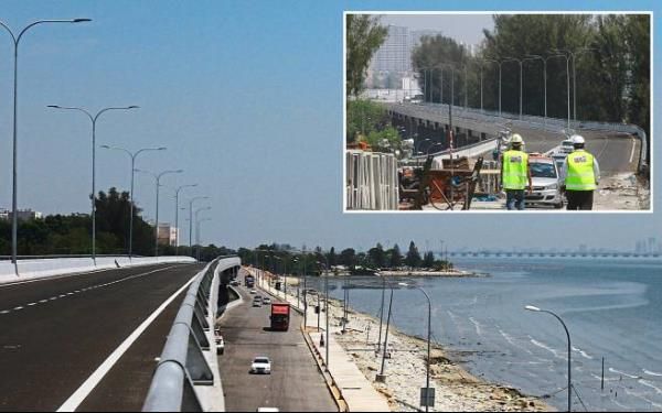
(Source for third photo: The Star)
Thanks.
The elevated expressway to facilitate access to the Penang 2nd bridge has been completed and is open to traffic. The mainstream media calls this elevated road Bayan Lepas Expressway (BLE) so we'll go with that. (The road below at ground level is still Tun Dr Lim Chong Eu Expressway.)
Other than the two ends, there are no exit/entry ramps on this elevated road. If you start from one end of this expressway, you will finish at the other end 3.3km later, no choice.
tympg 20160419 BLE.7z
(Source for third photo: The Star)
Thanks.
Garmin nüvi 2575R; Garmin eTrex Vista HCx; Android 5.0.1 Phone
-
moeyhc

- Valued Contributor
- Posts: 2240
- Joined: Wed Sep 17, 2008 10:53 am
- Location: Penang - Nuvi 300, 205W, 2575RLM, M1200, M1000B/C, Papago N1
Re: Penang Island Tracks Pt 4
Bro tympg.... Thank you very much for the update. 
I am too rusty to even remember how to turn on the 1 sec Track Log on my Nuvi... gave up after a few tries as I was late for my meeting....


Great to have members like you to keep it going...

I am too rusty to even remember how to turn on the 1 sec Track Log on my Nuvi... gave up after a few tries as I was late for my meeting....
Great to have members like you to keep it going...
Common Sense Is Not Common.
Re: Penang Island Tracks Pt 4
Auxiliary road leading to a place of worship.
tympg 20160420 aux-rd.7z
Thanks.
tympg 20160420 aux-rd.7z
Thanks.
Garmin nüvi 2575R; Garmin eTrex Vista HCx; Android 5.0.1 Phone
Re: Penang Island Tracks Pt 4
Two previously separate parts of a road have finally linked up.
Also, note that this road has a kink further back and is not a straight line as currently depicted in MFM-Garmin 160411.
tympg 20160421 OTS.7z
Thanks.
Done! 498 - OngCC
Also, note that this road has a kink further back and is not a straight line as currently depicted in MFM-Garmin 160411.
tympg 20160421 OTS.7z
Thanks.
Done! 498 - OngCC
Garmin nüvi 2575R; Garmin eTrex Vista HCx; Android 5.0.1 Phone
Re: Penang Island Tracks Pt 4
Add one U-turn; remove another U-turn.
tympg 20160501 U-turn.7z
Thanks.
Done! 499 - OngCC
tympg 20160501 U-turn.7z
Thanks.
Done! 499 - OngCC
Garmin nüvi 2575R; Garmin eTrex Vista HCx; Android 5.0.1 Phone
Re: Penang Island Tracks Pt 4
A road is upgraded, extended and now connects to another existing road.
tympg 20161117 road ext.7z
Thanks.
tympg 20161117 road ext.7z
Thanks.
Garmin nüvi 2575R; Garmin eTrex Vista HCx; Android 5.0.1 Phone
Re: Penang Island Tracks Pt 4
At Batu Maung, a major traffic junction is now a roundabout.
tympg 20161120 Bt Maung rndbt.7z
tympg 20161124 Mdn BLepas jct change.7z
Thanks.
Done! 513 - OngCC
- Some traffic lights have been removed; one traffic light junction is added.
- Many old roads have been removed. Some were inaccurate anyway, in my opinion.
- New roads are present, due to new property development in the area.
- Other changes are due by Q3 of 2017, including a flyover over this roundabout, and the complete upgrade to dual carriageway of P10.
tympg 20161120 Bt Maung rndbt.7z
tympg 20161124 Mdn BLepas jct change.7z
Thanks.
Done! 513 - OngCC
Garmin nüvi 2575R; Garmin eTrex Vista HCx; Android 5.0.1 Phone
Return to “Penang, Kedah & Perlis Map Feedback”
Who is online
Users browsing this forum: No registered users and 18 guests