Page 1 of 8
MFM Lane Assist Project
Posted: Wed Mar 21, 2012 7:04 pm
by zamad
bro
moeyhc started a thread on
Penang Junction Lane Assist Data Collection - JCLA way back in May 2009, but unfortunately that thread lasted only a month. See
viewtopic.php?f=4&t=2913Since now that
mfm maps are also being compiled by Garmin, wouldn't it be great if we could revive this project so that both JCV and LA can be displayed in future Garmin-released
mfm maps? The coding (by contributor) is way easier than the 'House Number search' project.

What do you think?
Re: MFM Lane Assist Project
Posted: Wed Mar 21, 2012 9:53 pm
by moeyhc
Wow! ..... I did that?...

fond memories now...
Agreed ... Let's work on it with renewed interest as it will be part of our Garmin-MfM map.
Are we gonna use the coding as stated? Let's standardize it for clarity. Your comments very much appreciated.
Re: MFM Lane Assist Project
Posted: Wed Mar 21, 2012 11:17 pm
by tympg
In future, we'll be entering Lane Assist details in our maps, not just for Garmin but other formats as well.
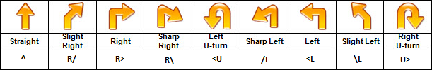
To start off, maybe something like this:
More to come...
Re: MFM Lane Assist Project
Posted: Thu Mar 22, 2012 9:42 am
by moeyhc
Bro, Thanks for your chart.
Next flyover, underground tunnels & etc....

p/s: who will collect these data?
Re: MFM Lane Assist Project
Posted: Thu Mar 22, 2012 11:01 am
by zamad
I'll try to put up some scenarios.
ONE:Travelling 'North' (up) at Junction 1:
The 2 left lanes go forward, the right-most lane turns right at the traffic light.
What would the code be? 1, 2, 3 or 4?
Or 'none of the above' ?
Re: MFM Lane Assist Project
Posted: Thu Mar 22, 2012 11:30 am
by tympg
zamad wrote:I'll try to put up some scenarios.
ONE:Travelling 'North' (up) at Junction 1:
The 2 left lanes go forward, the right-most lane turns right at the traffic light.
What would the code be? 1, 2, 3 or 4?
Or 'none of the above' ?
We will separate the lanes with semicolons. So, in your example above,
Having said that, we also need to establish a few more things:
- Junction reference (in your example above you have ID'd the junction as Junction 1. In practice, we could call the junction by its location e.g., Jct @ N4.xxxxx E.xxxxx
- Which road at the junction? We could label each road segment "Road A", "Road B" etc.
- Direction. Going TOWARDS the junction, or away FROM it?
More to come...
Re: MFM Lane Assist Project
Posted: Thu Mar 22, 2012 11:32 am
by tlchuan
No 1 too close
No 2 should be ok for me
Re: MFM Lane Assist Project
Posted: Thu Mar 22, 2012 11:45 am
by moeyhc
tympg wrote:We will separate the lanes with semicolons. So, in your example above,
Having said that, we also need to establish a few more things:
- Junction reference (in your example above you have ID'd the junction as Junction 1. In practice, we could call the junction by its location e.g., Jct @ N4.xxxxx E.xxxxx
- Which road at the junction? We could label each road segment "Road A", "Road B" etc.
- Direction. Going TOWARDS the junction, or away FROM it?
More to come...
I prefer to use a new POI to indicate a Junction. It will take away any dispute of labeling and orientation. So, a crossroad will have 4 POIs on all four sides of the junctions.
Naming of the junction can be
JCT-give a name-a to (n) so that they will group together in Mapsource for ease of work. What do you think?
Re: MFM Lane Assist Project
Posted: Thu Mar 22, 2012 11:48 am
by tympg
I suggest one junction at a time per report/submission so as not to confuse the mapper (and yourself).
Re: MFM Lane Assist Project
Posted: Thu Mar 22, 2012 11:53 am
by tympg
By the way, if the lane is straight and right, we just add the codes together.
Example:
Left lane is Go Straight
Middle lane is Go Straight or Turn Right
Right lane is Turn Right
The code would be: