Singapore - Feedback (Q2 2009)
Moderators: Chuah, Moderators, Regional Mappers
Singapore - Feedback (Q2 2009)
Please report any routing error, typo error, turn restriction & illegal u-turn here.
Upload your contribution to MFM drop box if you don't want others to take your contributed tracklogs or POIs.
http://www.malfreemaps.com/viewtopic.php?f=4&t=11630
http://www.malfreemaps.com/viewtopic.php?f=4&t=11630
Re: Singapore - Feedback (Q2 2009)
Hougang Ave 1 does not stop as currently shown in the latest map, but goes round the estate to join Lorong Ah Soo again next to Paya Lebar Methodist Girls School and 530128.
This road is officially part of Hougang Ave 1 and not a carpark access road as many assume (see LTA map and street directories).
Thanks! Already reported by someone else earlier. - OngCC
This road is officially part of Hougang Ave 1 and not a carpark access road as many assume (see LTA map and street directories).
Thanks! Already reported by someone else earlier. - OngCC
Garmin etrex Legend C, 10x + Garmin Mobile xt.
Holux 236, M1000 + Garmin Que & Mapking.
Holux 62Pro + Papago X2.
Holux 236, M1000 + Garmin Que & Mapking.
Holux 62Pro + Papago X2.
Re: Singapore - Feedback (Q2 2009)
Based on v.1.51:
Found a new open single lane right turn which allow to make a right turn directly across to Macrichie Reservoir Road Entrance (Macrichie Reservoir new car park) from the other side traffic for those coming from Ang Mo Kio/Upper Thomson/Bredell Rd towards Macrichie Reservoir.
The right turn is located after the Reservoir traffic lights juction which is exactly opposite the Macrichie Reservoir Rd Entrance ( new Car park entrance).
I believed it has been opened for quite some time.
My Nuvi 200W cannot locte the exact position at the right turn point which I taken the picture.
Checked the MFM map found no open right turn indicated/drawn neither MSM in the map.
Good news for those morning exercisers to Macrichie Park coming from abovetioned rd to make use of the newly open right turn.
Traffic is heavy in the morning at the Ronie Rd fly over.
Please corrected the map.
Thanks.
Any coordinates? Any picture? I'm not able to correct it with only these info... - OngCC
Found a new open single lane right turn which allow to make a right turn directly across to Macrichie Reservoir Road Entrance (Macrichie Reservoir new car park) from the other side traffic for those coming from Ang Mo Kio/Upper Thomson/Bredell Rd towards Macrichie Reservoir.
The right turn is located after the Reservoir traffic lights juction which is exactly opposite the Macrichie Reservoir Rd Entrance ( new Car park entrance).
I believed it has been opened for quite some time.
My Nuvi 200W cannot locte the exact position at the right turn point which I taken the picture.
Checked the MFM map found no open right turn indicated/drawn neither MSM in the map.
Good news for those morning exercisers to Macrichie Park coming from abovetioned rd to make use of the newly open right turn.
Traffic is heavy in the morning at the Ronie Rd fly over.
Please corrected the map.
Thanks.
Any coordinates? Any picture? I'm not able to correct it with only these info...
Re: Singapore - Feedback (Q2 2009)
Can someone verify if the missing runway in Singapore is intentional or error on my gps.
Thanks.
Thanks! - OngCC
You do not have the required permissions to view the files attached to this post.
Re: Singapore - Feedback (Q2 2009)
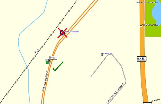
v1.51
Esso Station located wrongly.

Thanks! - OngCC
Esso Station located wrongly.

Thanks! - OngCC
You do not have the required permissions to view the files attached to this post.
Re: Singapore - Feedback (Q2 2009)
Based on v1.51
When routing to Jurong bird park from Jurong town hall road, while travelling on AYE towards Tuas, when approaching Penjuru Exit, the GPS will prompt to keep right on Ayer Rajah Expressway instead of remaining silent as I'm already travelling on the highway.
Coordinates of this error are
N01 19.553
E103 44.413
Another error of the same thing is at Clementi Road towards West Coast Highway, at the exit to AYE (Tuas) it will tell u to keep right on clementi road when I'm already on the road.
Coordinates are
N01 18.246
E103 46.280
Thank you.
Can you confirm again is 1.51? I tested on GMPC no voice prompt at the mentioned coordinates. - OngCC
Re: Singapore - Feedback (Q2 2009)
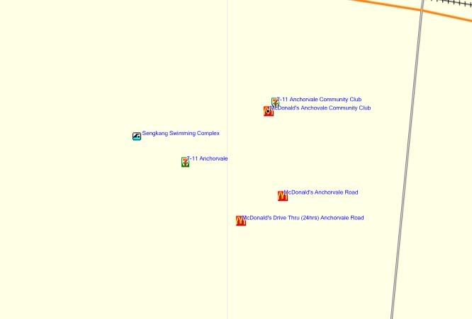
v1.51
Duplicate 7 Eleven icons.
Triplicate MacDonald's icons.
Sengkang Swimming Complex should be named Sengkang Sports Complex.
Please also add Anchorvale Community Club.

Thanks! - OngCC
Duplicate 7 Eleven icons.
Triplicate MacDonald's icons.
Sengkang Swimming Complex should be named Sengkang Sports Complex.
Please also add Anchorvale Community Club.

Thanks! - OngCC
You do not have the required permissions to view the files attached to this post.
Re: Singapore - Feedback (Q2 2009)
1) No right turn into Kent Vale
Yellow shows correct route. Magenta shows wrong.
Thanks!

Thanks! - OngCC
Yellow shows correct route. Magenta shows wrong.
Thanks!

Thanks! - OngCC
You do not have the required permissions to view the files attached to this post.
Re: Singapore - Feedback (Q2 2009)
epi wrote:Based on v.1.51:
Found a new open single lane right turn which allow to make a right turn directly across to Macrichie Reservoir Road Entrance (Macrichie Reservoir new car park) from the other side traffic for those coming from Ang Mo Kio/Upper Thomson/Bredell Rd towards Macrichie Reservoir.
The right turn is located after the Reservoir traffic lights juction which is exactly opposite the Macrichie Reservoir Rd Entrance ( new Car park entrance).
I believed it has been opened for quite some time.
My Nuvi 200W cannot locte the exact position at the right turn point which I taken the picture.
Checked the MFM map found no open right turn indicated/drawn neither MSM in the map.
Good news for those morning exercisers to Macrichie Park coming from abovetioned rd to make use of the newly open right turn.
Traffic is heavy in the morning at the Rornie Rd fly over.
Please corrected the map.
Thanks.
Tomorrow I will be going there.
Trying to contribute.
To take some camera photos. or hand carry Nuvi to the location to save the coordinates..?
Any coordinates? Any picture? I'm not able to correct it with only these info...- OngCC
Thanks! - OngCC
-
indrapr
- Valued Contributor
- Posts: 198
- Joined: Fri Sep 19, 2008 3:06 pm
- Location: Singapore (Garmin Nuvi 2565LM)
- Contact:
Re: Singapore - Feedback (Q2 2009)
Based on v1.51:
Jalan Serene is a no-through road (dead end), and it's only used to enter and exit the Serene Centre carpark. There is no through road into Cluny Park Road. See attached gdb file.
Thank you.
Thanks! - OngCC
Jalan Serene is a no-through road (dead end), and it's only used to enter and exit the Serene Centre carpark. There is no through road into Cluny Park Road. See attached gdb file.
Thank you.
Thanks! - OngCC
You do not have the required permissions to view the files attached to this post.
Who is online
Users browsing this forum: No registered users and 1 guest

