3DField is a contouring surface plotting and 3D data program that runs under Microsoft Windows 95/98/2000/XP. 3DField converts your data into contour maps and surface plots. All aspects of 2D or 3D maps can be customized to produce exactly the presentation you want.
Our members in MFM can get this software using this link:
http://field.hypermart.net/
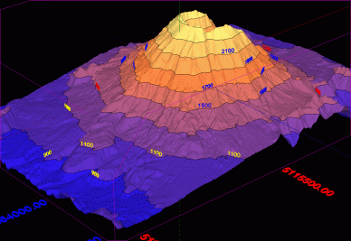
When I tried using with SRTM data from Antyong, it's look OK(must study more...
FauSham Rating:
We can use any of this file with 3DField:
- scattered (X,Y,Z) data points (up to a few million for registered version) ;
- scattered (X,Y,Z, links) data points with links;
- *.SHP files (ArcView ESRI Shapefiles);
- GPS NMEA files (elevations or depths);
- ASCII *.DEM USGS Digital Elevation Model files;
- ASCII *.DXF Autocad files (points and lines entities);
- ASCII *.GEN ArcInfo files (polygons);
- *.CSV files from SonarViewer (Lowrance Electronics, Inc);
- *.SLG Lowrance Sonar Log Data files using SLG2TXT utility from Lowrance Customer Service;
- *.GRD Surfer 6, Surfer7 and Surfer8 files;
- *.ASC ArcInfo compatible ASCII grid format;
- 1" and 3" SRTM data in HGT format (with .HGT extension)
- *.DBF DBase files;
- BMP, JPG, PNG, GIF, TIFF, GeoTIFF pictures;
- *.3DF 3DField documents;
- *.PNG files with the 3DField data inside logo.
GPS Data compatible:
Cetus for Palm/OS
CoPilot Flight Planner for Palm/OS
DeLorme GPL
DeLorme (drawing) file
DeLorme Street Atlas Route
EasyGPS binary format
Garmin Mapsource (Garmin PCX5;)
GeocachingDB for Palm/OS
GeoGrid-Viewer
GeoNiche .pdb
GpilotS
GPSPilot Tracker for Palm/OS
Holux (gm-100) Format
KuDaTa PsiTrex text
Lowrance USR
Magellan NAV Companion for Palm/OS
Magellan serial protocol
Magellan SD files (as for Meridian)
Magellan SD files (as for eXplorist)
Motorrad Routenplaner (Map & Guide)
MS PocketStreets 2002 Pushpin
National Geographic Topo
NMEA 0183 sentences
Quovadis
OziExplorer
PathAway Database for Palm/OS
TomTom POI file
TopoMapPro Places File
Vito Navigator II tracks
U.S. Census Bureau Tiger Mapping Service
POI (Point-Of-Interest for this software):
#4D project 3DFieldPro new version:
- Volume gridding for 4D scattered points by 4 gridding methods;
- Create isosurfaces and 3D planes;
- 3D model with irregular grid;
- All options of 3DField.
# 7 gridding methods (Radial Basis Functions, Inverse Distances, Triangulation, Kriging, Minimum Curvature, Natural Neighbors, Linear System )
# Automatic or user-defined contour intervals and ranges
# Control over contour label format, font, frequency and spacing
# Automatic or user-defined color for contour lines
# Color and texture fill between contours, either user-specified or as an automatic spectrum of your choice
# Base map attached to data points
# Data analysis, histogram for scatered points and interpolated grid values
# Regression 2D data
# Splines for lines and contours
# View and zoom BMP, GIF, PNG, JPG, TIFF and GeoTIFF images
# Automatically and manually digitize image
# Import and export lines
# Ascending or descending sort for values or coordinates of points
# OpenGL view with full screen rotation.
# Textures
# Convert a contour bitmap to a 3D view
# Output maps as EMF, WMF, BMP, JPG, PNG, GeoTIFF file formats
# Insert maps (EMF or bitmap) in any document Microsoft Office
# Multipage scale print
# Multilingual interface


 & then transfer it into Nuvi?????