
eTrex Series
Moderators: Moderators, Regional Mappers
Forum rules
1. Be nice to each other and respect the moderators. Post in normal font size, color and weight. Follow Nettiquette
2. NO out of topic. Discuss about GPS device only
3. NO abuse, profanity and insults
4. NO spamming, cross posting and opening of duplicate topics
5. NO advertisement post or link
6. NO post/link to warez, cracks, serials or illegally obtained copyrighted content
7. Each message posted is owned by and is the opinion of the original poster. Neither mfm nor its owner or moderators are legally responsible for anything posted on the forum
-
silverbeauty

- Moderator
- Posts: 3526
- Joined: Tue Sep 16, 2008 6:29 pm
- Location: Sin-Ka-Pu-Ra Garmin Nüvi1350, 3790T, Fenix, eTrex HcX Panasonic ICE+Garmin Samsung Note3 Apple iPad3
Re: eTrex Series
There are several ways to combine maps ie.. via Mapsource, ezmap, GMaptools .....
Re: eTrex Series
silverbeauty wrote:There are several ways to combine maps ie.. via Mapsource, ezmap, GMaptools .....
i got mapsource. will the help file in mapsource teach how to combine?
my idea of combine is tht i can take 2 diff maps of s'pore and combine them so tht i can have the best of both maps
Re: eTrex Series
silverbeauty wrote:Below is as extracted from Garmin eTrex manual ( page 44 ) explaining what the "D" alphabet appearing on the signal bar means.
http://www8.garmin.com/manuals/eTrex_Ow ... above_.pdf
WAAS Capability
The eTrex is capable of receiving WAAS (Wide Area Augmentation System) satellite
signals. WAAS is an FAA (Federal Aviation Administration) funded project to improve the
overall accuracy and integrity of the GPS signal for aviation use, but land/sea based users may
also benefit from this system. There are currently two WAAS satellites that can be received
in the U.S.A., one over the Atlantic Ocean and one over the Pacific Ocean, in a geo-stationary
orbit over the equator. Effective use of the WAAS satellite signal may be limited by your
geographic location in relation to those satellites. WAAS is most effective for users in the
continental U.S. WAAS satellite signal reception requires an absolute clear view of the sky and
works best when there are no nearby obstructions such as buildings or mountains. WAAS
satellites are numbered 33 or higher when viewing the sky view on your eTrex. Initial reception
of the WAAS signal may take up to 15–20 minutes, then 1–2 minutes afterwards. When
WAAS differential correction has been received for GPS satellites (numbers 32 or below), a
‘D’ appears in the signal bar of the Advanced Sky View. When enough satellites have received
WAAS differential correction, ‘DIFF’ appears below the ‘Ready to Navigate’ message.
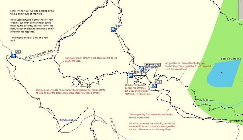
Thanks Bro silverbeauty for the explanations, only at certain places I can receive the "D" signal, when inside jungle, can't receive at all. It only shows "Location +/- 7 metres" like that.
-
fauzee

- Polygon Mapper
- Posts: 1243
- Joined: Fri Feb 06, 2009 9:19 pm
- Location: JB and Muar -200W & 60Csx
Re: eTrex Series
lfy81 wrote:Ok my simple review of my etrex Legend HCx, sensitive but not accurate enough.
A clearer and bigger picture in this below link because my picture upload limit is 800pixels
http://img.photobucket.com/albums/v502/ ... llse-1.jpg
Bro..i just analysed your problem..my question is..did u set your GPS in Battery Saver Mode??? If yes..u got your answer on this..First, when u gonna use the Battery Saver mode?..this mode u can use only for navigation..coz the accuracy not mantained and always increase and decrease...like 3m,7m,12m,58m...12m..b'coz the device need more power to maintained the accuracy but selecting Batt Sav Mod may reduce power usage (more hour can go) and then the device not work very hard to archieve -/+3m~6m signal, but enough if still have some signal to Navigate....but as long as your e-trex have signal..no problem with navigation..Second, if u select Normal Mode..your device work so hard to maintained accuracy and you got -/+3m at all times..mean it will use more power and your battery have a short hour spend..and don't remember to have some spare Batt.


~Lost Is Nothing~
...PLEASE INSTALL THE LATEST MAPS BEFORE DOIN' SOMETHIN'...
...PLEASE INSTALL THE LATEST MAPS BEFORE DOIN' SOMETHIN'...
-
kiwitonita
- Posts: 4
- Joined: Tue Feb 24, 2009 4:28 pm
- Location: Christchurch, New Zealand
- Contact:
Re: eTrex Series
redname wrote:i got mapsource. will the help file in mapsource teach how to combine? my idea of combine is tht i can take 2 diff maps of s'pore and combine them so tht i can have the best of both maps
Yes, it's very easy to combine different maps - I often combine street, topo and marine (a mixture of Open Project and Garmin maps) for New Zealand so the complete map set is on one card (or internal memory) - you're basically limited only by the memory size. Read the MapSource Help or download the short MapSource Tutorial video from Garmin here http://www8.garmin.com/cartography/mapsourceTutorial.html
Re: eTrex Series
fauzee wrote:lfy81 wrote:Ok my simple review of my etrex Legend HCx, sensitive but not accurate enough.
A clearer and bigger picture in this below link because my picture upload limit is 800pixels
http://img.photobucket.com/albums/v502/ ... llse-1.jpg
Bro..i just analysed your problem..my question is..did u set your GPS in Battery Saver Mode??? If yes..u got your answer on this..First, when u gonna use the Battery Saver mode?..this mode u can use only for navigation..coz the accuracy not mantained and always increase and decrease...like 3m,7m,12m,58m...12m..b'coz the device need more power to maintained the accuracy but selecting Batt Sav Mod may reduce power usage (more hour can go) and then the device not work very hard to archieve -/+3m~6m signal, but enough if still have some signal to Navigate....but as long as your e-trex have signal..no problem with navigation..Second, if u select Normal Mode..your device work so hard to maintained accuracy and you got -/+3m at all times..mean it will use more power and your battery have a short hour spend..and don't remember to have some spare Batt...others mode is GPS Off and Demo Mode(don;t know how to use
)...about WAAS..i still believed it can help accuracy more strong..Only God knows why..
Bro, thanks for your explanations
, but my Legend HCx, does not have battery mode, only Normal, GPS Off, Demo Mode.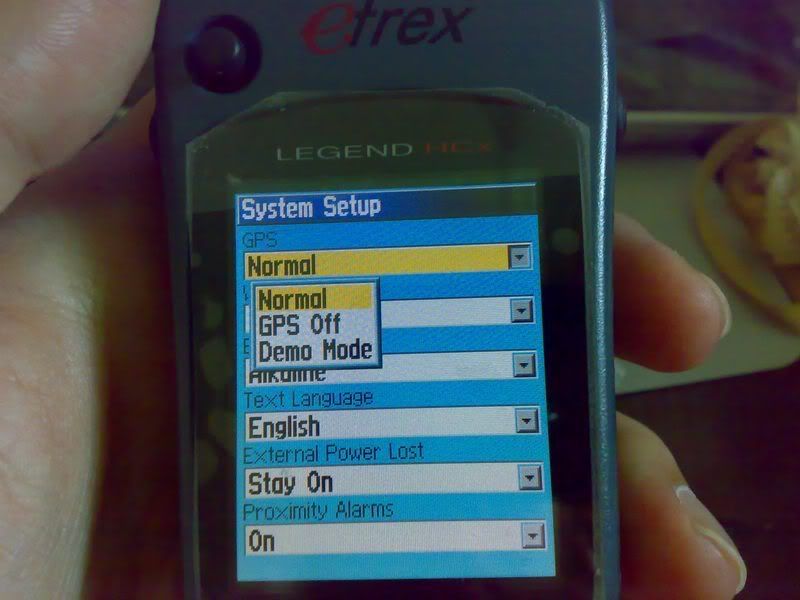
BTW, wanna ask something, normally for tracking settings, is this correct to use, I am using these settings not sure is the right setting or not.
Record method, I chose Auto, other option is Distance and Time, not sure how to use.
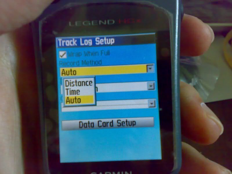
Interval I chose Most Often
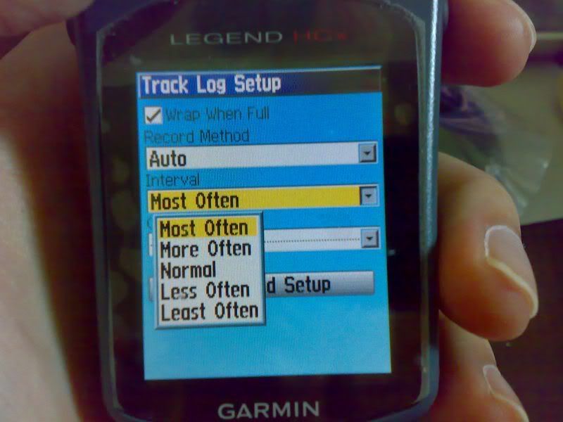
Just wondering which setting is best to get better accuracy.
-
kiwitonita
- Posts: 4
- Joined: Tue Feb 24, 2009 4:28 pm
- Location: Christchurch, New Zealand
- Contact:
Re: eTrex Series
For the best record, choose Time and an interval of 1 second. Obviously this is going to give you thousands of points in a short time (regardless of distance traveled) and will fill the internal 10,000 track point memory. So you need to consider just how much accuracy you need.
Likewise if you need to know where you were every 10m (regardless of the time interval) for example, choose the Distance > 0.01km setting.
A very handy alternative is recording your tracks onto the data card - the GPS uses the spare card space where even 100MB will hold over 900,000 points. There's bound to be comprehensive information on this forum about that feature (I'm new here) but it's done in the Tracks > Setup > Data Card Setup menu. The GPS will create dated gpx files in there. Unfortunately MapSource does not see these files directly - you need to either put the card in a card reader or put the GPS into Mass Storage Mode (Setup > Interface)
1 second logs (with Lock on Road selected to Off) are good for helping the mappers but a bit over the top for most other things. Auto and Normal are fine for general purpose. The Auto setting lets the GPS apply a bit of intelligence and does not waste points on straight roads, saving them for corners.
Re: eTrex Series
kiwitonita wrote:For the best record, choose Time and an interval of 1 second. Obviously this is going to give you thousands of points in a short time (regardless of distance traveled) and will fill the internal 10,000 track point memory. So you need to consider just how much accuracy you need.
Likewise if you need to know where you were every 10m (regardless of the time interval) for example, choose the Distance > 0.01km setting.
A very handy alternative is recording your tracks onto the data card - the GPS uses the spare card space where even 100MB will hold over 900,000 points. There's bound to be comprehensive information on this forum about that feature (I'm new here) but it's done in the Tracks > Setup > Data Card Setup menu. The GPS will create dated gpx files in there. Unfortunately MapSource does not see these files directly - you need to either put the card in a card reader or put the GPS into Mass Storage Mode (Setup > Interface)
1 second logs (with Lock on Road selected to Off) are good for helping the mappers but a bit over the top for most other things. Auto and Normal are fine for general purpose. The Auto setting lets the GPS apply a bit of intelligence and does not waste points on straight roads, saving them for corners.
Bro kiwitonita, thanks, now I set my Legend HCx on "Time" 1 seconds interval. My trekking usually is around 1.5 hours. Should be enough points, I think.
About the bolded part, is it possible that Mapsource is able to open the gpx files after being transfered to the PC?
I might try saving my GPS log into my memory card tomorrow as an experiment and later transfer to the PC, and see if Mapsource would open the file.

Re: eTrex Series
fauzee wrote:..about WAAS..i still believed it can help accuracy more strong..Only God knows why..
alamak, if this article doesn't convince you that WAAS does not work outside of North America, I don't know what will.
http://www8.garmin.com/aboutGPS/waas.html
Enabling the WAAS outside of North America is not recommended because it will induce error in the fix.
Contribute exclusively to MFM. MSM don't get it !
-
fauzee
- Polygon Mapper
- Posts: 1243
- Joined: Fri Feb 06, 2009 9:19 pm
- Location: JB and Muar -200W & 60Csx
Re: eTrex Series
Who benefits from WAAS/EGNOS?
Currently, WAAS satellite coverage is only available in North America. There are no ground reference stations in South America, so even though GPS users there can receive WAAS, the signal has not been corrected and thus would not improve the accuracy of their unit. For some users in the U.S., the position of the satellites over the equator makes it difficult to receive the signals when trees or mountains obstruct the view of the horizon. WAAS signal reception is ideal for open land and marine applications. WAAS provides extended coverage both inland and offshore compared to the land-based DGPS (differential GPS) system. Another benefit of WAAS is that it does not require additional receiving equipment, while DGPS does.
Other governments are developing similar satellite-based differential systems. In Asia, it's the Japanese Multi-Functional Satellite Augmentation System (MSAS), while Europe has the Euro Geostationary Navigation Overlay Service (EGNOS). Eventually, GPS users around the world will have access to precise position data using these and other compatible systems
EGNOS never stated any limitation on satellite coverage..

~Lost Is Nothing~
...PLEASE INSTALL THE LATEST MAPS BEFORE DOIN' SOMETHIN'...
...PLEASE INSTALL THE LATEST MAPS BEFORE DOIN' SOMETHIN'...
Who is online
Users browsing this forum: No registered users and 25 guests